Industries
Industry Expertise, Real-World Impact
No two industries use GIS the same way. UDF Tech Services adapts our solutions to your sector’s unique challenges—whether that’s optimising supply chains, monitoring the environment, or planning smart cities.


Urban Planning & Development
Plan smarter, build better, and manage growth with GIS-powered analysis and visualization.
- Model land use and infrastructure needs.
- Create dynamic 3D city models for public engagement.
- Track zoning changes and urban expansion.
Environmental Monitoring & Sustainability
Monitor ecosystems, track environmental changes, and support conservation efforts.
- Use remote sensing to detect deforestation, erosion, or water quality changes.
- Predict environmental risks with AI-driven analysis.
- Integrate monitoring data into actionable sustainability plans.
Transport & Logistics
Streamline routes, reduce costs, and respond to real-time events with spatial intelligence.
- Optimize delivery networks and fleet management.
- Use real-time GIS for live tracking and incident management.
- Plan infrastructure projects with precise geospatial data.
Telecommunications & Utilities
Plan, monitor, and maintain critical infrastructure with precision.
- Map existing networks and plan expansions.
- Identify ideal locations for towers or substations.
- Use LiDAR and 3D GIS for terrain and structure analysis.


Retail & Real Estate
Choose locations and understand markets with location-driven insights.
- Perform site selection based on demographics, traffic, and competition.
- Visualize catchment areas and customer patterns.
- Using predictive modeling to plan future expansion.
Government & the Public Sector
Support public services, safety, and policy-making with powerful GIS tools.
- Map emergency services coverage and response times.
- Manage infrastructure and assets with digital mapping.
- Facilitate open data portals for public transparency.
Agriculture & Forestry
Increase yields, manage resources, and monitor land with precision agriculture tools.
- Use satellite imagery to track crop health and soil conditions.
- Optimize irrigation and planting schedules.
- Monitor deforestation and land use changes over time.
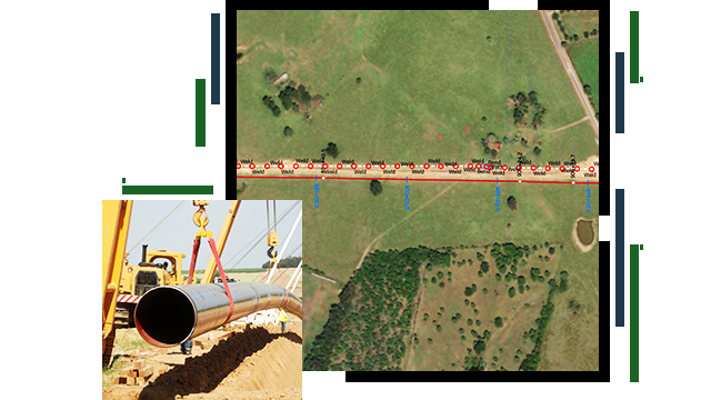
Energy & Natural Resources
Manage exploration, extraction, and distribution with accurate spatial data.
- Plan pipelines, transmission lines, and facilities.
- Monitor your environmental impact in real time.
- Using predictive analytics for maintenance and safety.
Why Our Industry Approach Works
This enables stakeholders to view and interact with terrain, buildings, and infrastructure as they exist in real life—or as they could exist in the future.
Custom Solutions
We tailor tools to each sector’s needs.
Proven Track Record
Successfully deployed GIS solutions in diverse environments.
Cross-industry Learning
We bring fresh ideas from other sectors to your challenges.